Climate
|
Scotland has a cool temperate climate because of the golf stream, arriving from the Atlantic Ocean. This means that the weather in Scotland is not usually very hot in the summer and quite often mild in the winter. The average temperature in the low-lying areas is no more than 15-20 degrees Celsius during the summer.
Scotland is also known for its very wet weather. However, the rain varies a lot from one part of the country to another. In some places in the Highlands, for example, the annual rainfall is very high, sometimes up towards 3000mm in one year, and on the east coast it might be around 650 mm per year.
|
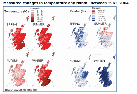
Photo by www.forestry.gov.uk
|
The regions |
http://www.forestry.gov.uk/fr/INFD-79RGKS
|
Map of Scotland
 http://en.wikipedia.org/ http://en.wikipedia.org/
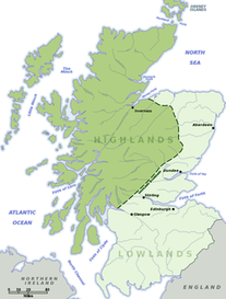
The Highlands and Islands: The Highlands cover about two thirds of the country but is not populated as much as the lowlands because of the many mountains and strained conditions. And of the 790 islands around Scotland only 130 are inhabited.
Central Lowlands: Triangular shape market in the corners by the cities: Edinburg, Glasgow and Dundeee. Most of the population in Scotland lives here. Forests and Woodlands: The Highla1nds landscapes have very few trees because farmers and landowners have cleared it the last few hundred years. 90% of the forest is made up of nonnative conifer trees, which is a good way of making money but a bad thing for the land because the trees grow so close together that nothing else can live in the forest. 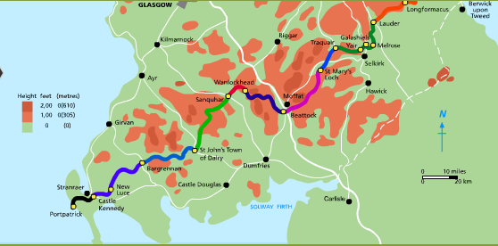
http://www.southernuplandway.gov.uk/cms/
|
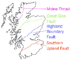
Southern UplandThe Southern Upland is an area which lies between the English-Scottish border and the industrial belt between Glasgow and Edinburgh. Which is also reffered to as the Highland Boundary Fualt.
Mainly, this area is a hill landscape, especially in the central area and along the border. Flat plains are found along the coast, which are often used as farming land because of its fertile soil. The Southern Uplands have always formed a major travelling obstacle between the more heavily populated and industrialized Central Belt of Scotland and England to the south. The Southern Upland way:
The Southern Uplands Way is Britain's very first official coast to coast long distance foot path. It is a path of 340 km (212 miles) from Portpatrick in to south-west coast of Scotland to Cockburnpath on the eastern seaboard. What is to be experienced by "the Way" is a superb and varied walking country, still undiscovered by many enthusiasts. It is suitable for both the less ambitious/families along the shorter stretches , and also the more experienced walker can experience a real challenge. |
Central LowlandsCentral Lowlands consists of a rift valley between the Highland Boundary Fault to the north and the Southern Uplands Fault to the south. Triangular shape marked by the corners by the cities: Edinburg, Glasgow and Dundeee. Most of Scottish population lives in this region because of job possibilities.
|
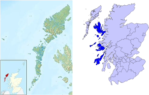
The islandsScotland is made up of three main regions: The Southern Upland, The Central Lowlands and The Highlands and Islands.
|
 http://en.wikipedia.org/
Outer Hebrides:
Lewis and Harris (Scottish Gaelic: Leòdhas agus na Hearadh) in the Outer Hebrides make up the largest island in Scotland. This is the largest single island of the British Isles after Great Britain and Ireland.
Inner Hebrides:
At 1,656 square kilometres (639 sq mi), the Isle of Skye is the second-largest island in Scotland after Lewis and Harris.
